These numbers are between 6°C and 10°C higher than the seasonal average.
Remember last week’s heat dome? We’re sorry to say that it’s still going strong.
Local weather page It-Temp Madwarna took to social media to announce that, not only is the summer’s second heatwave still persisting, but it’s also getting stronger.
“The North-African anticyclone is currently stuck over the centre of the Mediterranean Sea, where an intense heat dome has also been established,” the page revealed.
As a result of this, “weather throughout the week will be sunny and warm, with skies set to get even foggier throughout the second half of the week. The UV Index is expected to reach highs of 11 and over.”
𝗜𝗦-𝗦𝗛𝗔𝗡𝗔 𝗧𝗜𝗡𝗧𝗘𝗡𝗦𝗜𝗙𝗜𝗞𝗔 𝗜𝗭̇𝗝𝗘𝗗 Analiżi: L-antiċiklun Nord-Afrikan jinsab imwaħħal u se jkompli jissaħħaħ fiċ-ċentru...
Posted by It-Temp Madwarna on Sunday, June 26, 2022
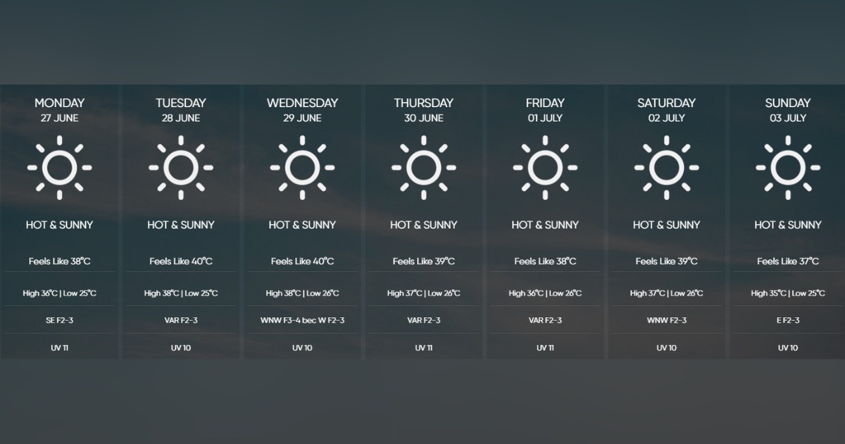
It-Temp Madwarna noted that temperatures will reach highs of at least 36°C every day this week, although they’re expected to reach a whopping 40°C tomorrow, Tuesday 28th June.
These numbers are between 6°C and 10°C higher than the seasonal average.
Similarly, minimum temperatures will increase to anywhere between 24°C and 27°C, the page added.
The Malta International Airport’s meteorological office is predicting a similar although slightly less intense increase in temperatures.
maltairport.com
Like It-Temp Madwarna, MIA is expecting the week’s temperatures to reach their climax on Tuesday 28th and Wednesday 29th, forecasting highs of 38°C which will “feel like 40°C”.
The met office has also gone ahead and issued a yellow warning in lieu of the intense heat impacting the islands today, with highs of 36°C feeling like 38°C expected.
Winds will remain generally mild throughout the week, presumably because of the heat dome over the islands.
Sea temperatures have increased to an average of 23°C, which is in line with the seasonal average.
How are you coping with the summer heat?