Here's why it was probably at the Eye of Africa. But Malta was still related to it!
Search ‘Richat Structure Eye of Africa’ on YouTube and you are immediately served a nice long list of videos that offer ‘proof’ and ‘evidence’ that this place is indeed the location of the lost city of Atlantis, just as it was described by Plato.
Plato described Atlantis in the Critias and Timaeus dialogues 2,400 years ago. With the information previously passed on through generations by word of mouth, his are the most detailed accounts of the legendary Atlantis.

There have been several contenders for the possible location of Atlantis, including Malta, but all fail in some way to fulfill all the criteria Plato had laid out in its description. The Richat Structure, also known as the Eye of Africa, is surprisingly fitting.
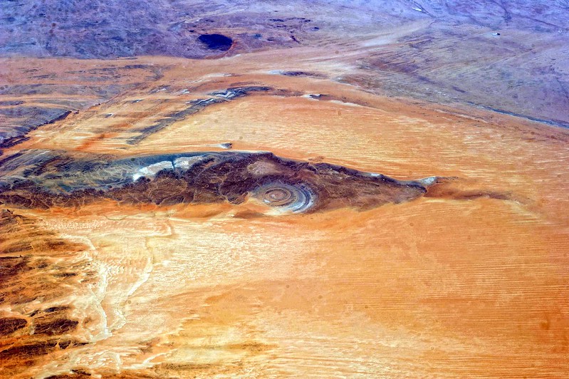
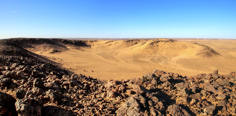
First discovered in the 1930s, the Richat Structure is a striking circular feature in the Sahara Desert in Mauritania. Originally thought to have been a crater, research in the 1950s and 1960s has since eliminated the possibility of it having been made by extraterrestrial impact (a meteor, for example) in favour of terrestrial causes (such as volcanic activity). Scientists settled for a theory that it is a 100-million-year-old dome of molten rock, eroded and shaped by wind and water.

However, in 2005, in a publication by the Macquarie University of Sydney, Australia, the author's wrote: "Several hypotheses have been presented to explain the spectacular Richat Structure and breccia, but their origin remains enigmatic," while a 2011 multi-analytical study (published in the Research Journal of Chemistry and Environment v. 15, no. 3) concluded that "the structure requires special protection and further investigation of its origin."
Needless to say, many speculators believe that the Richat Structure is not merely a geological wonder, unique in the whole world, but the location of the legendary 11,000-year-old city of Atlantis. Here are just a few of the correlations between Atlantis, as described by Plato, and the Richat Structure
1. King Atlas
"And to all of them he gave names, giving to him that was eldest and king the name after which the whole island was called and the sea spoken of as the Atlantic, because the first king who then reigned had the name of Atlas."
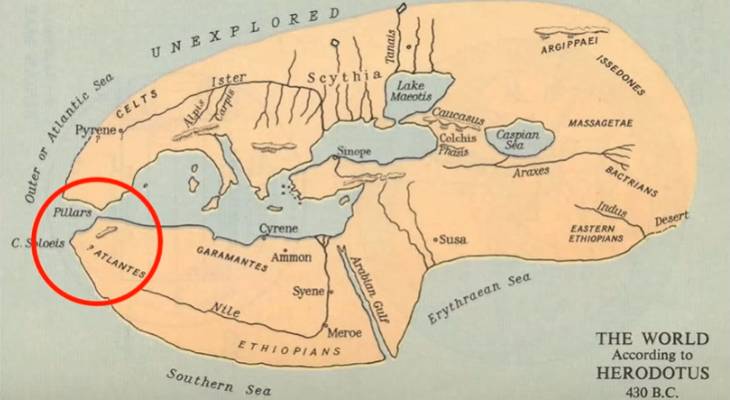
Plato describes how Atlas, who was Poseidon's first born of ten brothers, was appointed king to rule over all ten provinces of Atlantis. Coincidentally, Atlas was also the name of the first king of Mauritania, West Africa - the location of the Richat Structure - overlooking the Atlantic Ocean and having the Atlas mountains to the north. A map by Herodotus from 430 BC names that specific area Atlantes.
2. The accurate shape and size
"...alternate zones of sea and land larger and smaller, encircling one another; there were two of land and three of water…the part about the city was all a smooth plain, enclosing it round about, and being itself encircled by mountains ... [the plain] faced towards the South and was sheltered from the Northern blasts [by the mountains]."

Plato goes on to explain the area in great detail, including all the measurements. Also visible from space, the massive Richat Structure has two concentric bands of resistant quartzite rocks which form the ridges, with lower-level sedimentary rock between them. The layout and measurements of the concentric circles and the gateway to Atlantia (the name associated with the surrounding mountains, plain, fauna, coastline, etc.), including massive flat plains to the south and an entire mountain ridge to the north, fit Plato’s lengthy description.
3. The Eye of Africa was an island
"...the island of Atlantis, which was an island larger than Libya and Asia once upon a time…the whole region rose sheer out of the sea to a great height."
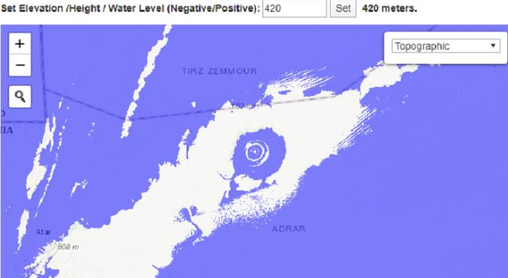
A FloodMap elevation of the sea level by 400-420 metres demonstrates how the rings would appear with the lake filled within a large island. Although the finding of marine fossils and bones in the area indicate that the area was certainly below sea level at various points in time, Plato describes how fresh waters ran from the mountains into a freshwater lake at the city of Atlantis and then ran towards the sea to the south, a channel that’s also present.
Plato’s remark that the island was larger than Libya and Asia might actually refer to north-west Africa’s apparent separation from the mainland by the ancient Tamanrasett River that ran from the Atlas mountains through what is now the Sahara Desert to the sea at Mauritania up to 7,000 years ago. With the sea level much lower, the lake would have been fed entirely by fresh water.
4. Freshwater is present to this day
"...two springs of water from beneath the earth, one of warm water and the other of cold, and making every variety of food to spring up abundantly from the soil."

The presence of a freshwater spring has been located in the centre of the Richat Structure, whereas the presence of a hot spring in the past was quite likely due to the volcanic activity beneath it. Furthermore, the area still tends to hold fresh rain water from streams running into it, growing vegetation in the middle of the desert to this day. The deeply weathered bedrock that formed the ridges was created under tropical environments, indicating the place was once lush, and many well-preserved freshwater fossils were found in the finer sandy deposits between them.
5. It is a land of elephants
"...it contained a very large stock of elephants; for there was an ample food-supply not only for all the other animals which haunt the marshes and lakes and rivers, or the mountains or the plains, but likewise also for this animal, which of its nature is the largest and most voracious."

The presence of elephants is a very important detail that certainly makes Africa a far more likely candidate for Atlantis than any of its European counterparts, including Malta. The African Elephant is known to have become extinct in Mauritania.
6. The local stones are a match
"And the stone they quarried beneath the central island all round, and from beneath the outer and inner circles, some of it being white, some black and some red ... some of their buildings were simple, but in others they put together different stones, varying the colour to please the eye, and to be a natural source of delight … It [the city] was fashioned by nature and by the labours of many generations of kings through long ages."
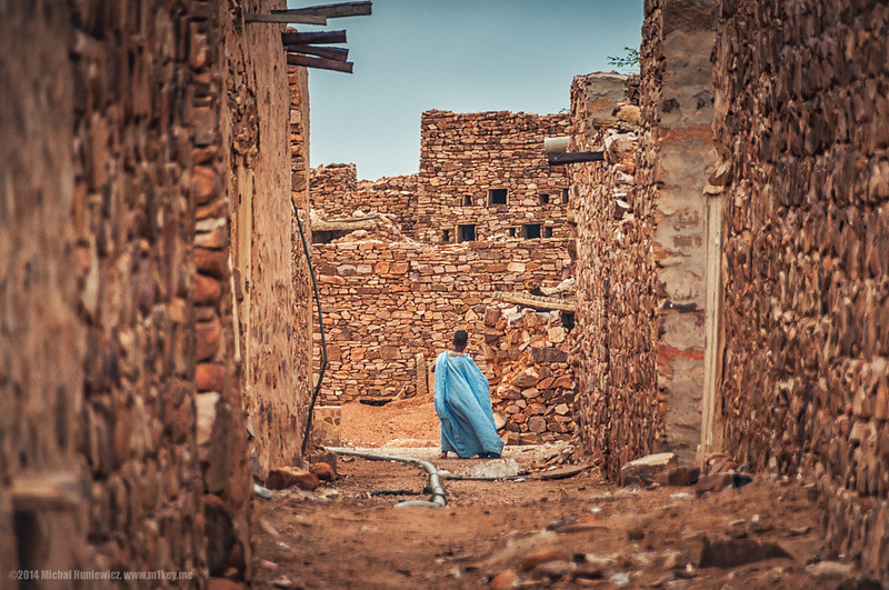
White, black and red stone is evident at the site and in the buildings of the nearby town of Ouadane. The stones are small, not megaliths of any sort, and the buildings rudimentary, so it would not be surprising that a massive flood would wash it all away and leave no trace. Interestingly, the absolutely flat levelled tops of the rings (quite ideal for building, though, hmm, could that be a natural phenomena?) are strewn with rubble!
7. Ancient artefacts were found at the site
"And round about it, on this side and on that, were barracks for the greater part of the spearmen; but the guard-house of the more trusty of them was posted in the smaller circle, which was nearer the Acropolis; while those who were the most trustworthy of all had dwellings granted to them within the Acropolis round about the persons of the kings."
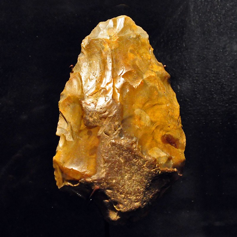
Exceptional accumulations of Acheulean artefacts, or stone spears and tools, of undetermined age and origin were found at the Richat Structure. That these were generally absent at its innermost depressions has been taken to indicate that the area was only used for short-term stone tool manufacturing and hunting, but this finding would also fit with the description that the outer circle was largely inhabited by working citizens and soldiers, with Atlantian Royalty in the middle.
8. Sub-Saharan DNA from a previously unknown ancient population

Only recently, DNA testing of the Taforalt skeletons - over thirty Iberomaurusian human skeletons from the Upper Palaeolithic that were found in a cave-cemetery in northern Oujda, Morocco - identified clear markers linking their 15,000-year-old DNA to sub-Saharan Africa. The DNA has some characteristics matching modern Hadza hunter-gatherers from East Africa and others matching modern West Africans, but the precise combination of characteristics of the Taforalt individuals matches no previously identified population. This suggests that their DNA heritage may come from a population that no longer exists.
9. The dating fits
"...9,000 is the sum of years since the war occurred, as is recorded, between the [Atlantean] dwellers beyond the pillars of Heracles [the Strait of Gibraltar] and all that dwelt within them."
The Iberomaurusians (people of Atlantes) may have fought the Sebilians and Harifians (people of Egypt) around 9,000 BC. Plato dates the war to 9,000 years before Solon (640-558BC), that’s around 11,000 years ago. Numerous, concordant radiocarbon dating indicates that the bulk of the sediments had accumulated at the Richat Structure between 15,000 and 8,000 BC. Interestingly, the meteor impact in Greenland that might well have spurred the earthquakes and floods may be as young as 12,000 years. All this dating aligns with Plato’s story.
10. There’s evidence of a flood
"...but afterwards there occurred violent earthquakes and flood; and in a single day and night of misfortune all your warlike men in a body sank into the earth, and the island of Atlantis in like manner disappeared in the depths of the sea."

The topography surrounding the Richat Structure supports the notion that Africa had suffered a gigantic flood. In satellite images, it looks as if something literally swept over the entire area towards the sea. The gravelly deposits include slope scree, debris flow and fluviatile, or even torrential flow, deposits, supporting Plato’s description that the area was flooded "within a single day and a night."
11. The Eye of Osiris
One look at the Richat Structure and it juggles to memory the symbol of the Eye of Osiris. Also known as the Eye of Horus, it is an ancient Egyptian symbol of protection, power and prosperity. Some even associate it with the shape of the pineal gland, that represents the Third Eye or Awareness of the Unseen. The Eye of Osiris is also represented on Maltese Luzzu boats, in an albeit different design, to this day. The symbol may have originated in Atlantis, because according to Plato:

"So all these, themselves and their descendants, dwelt for many generations, bearing rule over many other islands throughout the sea, and holding sway besides, as was previously stated, over the Mediterranean peoples as far as Aigyptos (Egypt) and Tyrrhenia [in Italy]."
The main argument against the Richat Structure as a possible location for Atlantis is that is currently stands at 423 metres above sea level, but perhaps there may be some explanations for this that we simply have not yet discovered. Whether or not the Richat Structure may really be Atlantis is subject to opinion, since no excavations have been made to the site. Do you think this site ought to be excavated?